Hiking Mount Muhabura in Uganda – Best time and Prices
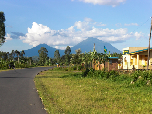
Mount Muhabura or “Muhavura” is an extinct volcano found on the border between Uganda, the Democratic Republic of Congo and Rwanda. One part of the volcano is found in Uganda’s Mgahinga National Park and another in Rwanda’s Volcanoes National Park. The Mountain stands at 4,127 meters above sea level and has the 3rd highest peak among the Virunga Ranges of mountains. Mount Karisimbi is the tallest followed by Mikeno. Though not the highest, Muhabura is the steepest of all the eight Volcanoes found 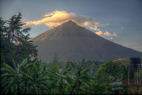 within the Virunga ranges. Mount Muhabura is very close to Mount Sabyinyo and Mount Gahinga. Muhabura means “the guide” in the local language. This name was coined probably because its massive size helped guide distant travelers.
Mount Muhavura is characterized by a cone-like shape with volcanic ash and other related materials on the slopes and at the foot. The Volcanic ash supports the group of shrubs and thickets on the sides of the mountains. The Kabiranyuma river/swamp is another prominent feature that separates Mount Muhabura from Mount Gahinga.
Climbing Mount Muhabura offers opportunities to spot rare species of birds and mammals like buffaloes, elephants and Mountain gorillas (especially from the Uganda side). The buffaloes can be dangerous to hikers because they are naturally aggressive but armed rangers are always on hand to scare them away just in case. You might be interested in the page about climbing Mount Kilimanjaro.
Hiking Mount Muhabura
Mount Muhabura is the most difficult mountain to hike among the 8 volcanoes in the Virunga Ranges. It may not be the tallest but it is very steep and yet one is required to complete the hike in one day (before 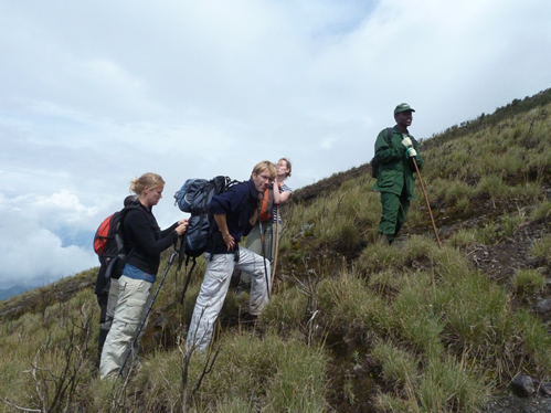 the sun sets). To reach the summit and descend on time, one needs to be mentally prepared and maybe a little stubborn. Hiking Mount Muhabura is arranged from both the Uganda and Rwanda side. If you are climbing mount Muhabura from the Uganda side, you will be met by the resident Guides from the Uganda Wildlife Authority. If hiking from the Rwanda side, you need to report to the Kinigi visitors center.
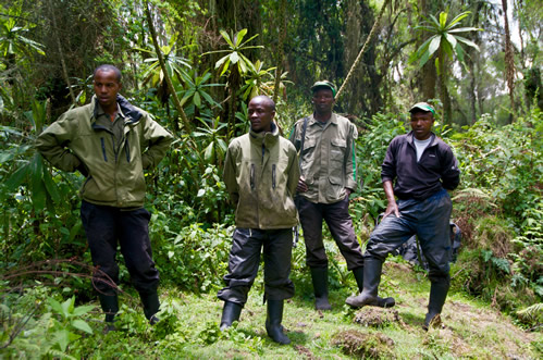
After paying at the offices, A Guide and Rangers will be assigned to your group who will lead you all the way up the mountain. If you are moving with heavy luggage or equipment, Porters are available for hire at the foot of the mountain. In case the group is large, hikers are usually split into two with one consisting of the slower hikers and another more experienced hikers. If it gets too late and you haven’t reached close to the summit, you are simply advised to give up and descend along with others who completed in time.
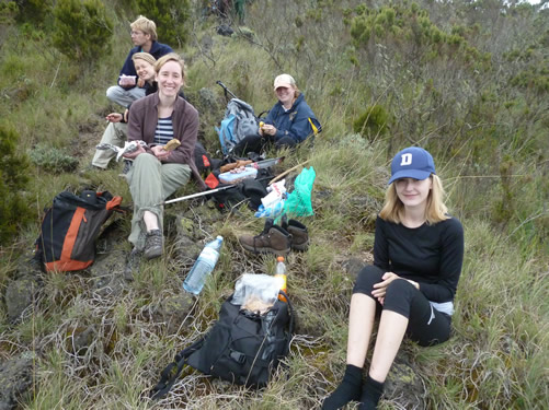
 Climbing Mount Muhabura starts at around 7am and takes between 5 to 7 hours to complete. Before heading off to the head trail, the Rangers will organize a briefing for all hikers. This briefing covers all important aspects of the hike and includes the history and formation of the mountain. The Rangers will advise hikers on how to prepare mentally for the activity and deal with any injuries or symptoms of altitude illness. During the briefing, the Rangers and Guides will also check to see if all hikers have the necessary gear, hiking boots, walking sticks, packed lunch, the right clothing or drinking water. All supplies and equipment have to be sorted out before proceeding to the head trail.
After the usual briefing, hikers are driven or taken to the starting point of the hike by the park authorities, their personal Driver or a Guide from their Tour company. Hiking Mount Muhavura is very demanding because it is steep. One needs to be very fit in order to complete the hike.
 Hiking Mount Muhabura from the Uganda side involves two major stops before reaching the summit. The first stop is at about 3,117 meters above sea level while the second is at about 3,860 meters above sea level. Some hikers do not make it past the first stop (hut). They simply rest, take their lunch and decide that enough is enough before returning back to the starting point. In fact, in most large groups, there are a few who may not make it to the top. Those that continue have to endure a more difficult hike to reach the second hut (stop). After the second stop, the hike becomes even more challenging. But by this time, there is no turning back because the summit is so near. To continue from this point onward requires more stamina, determination and a certain level of fitness. It gets colder and the mountain is often covered with mist. Some might suffer from altitude sickness or injuries to their ankles at this point.
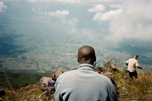
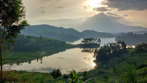
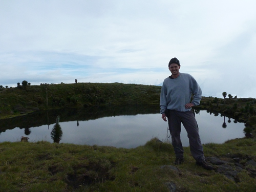 Those who make it all the way up to the top after such a challenging hike are rewarded with breathtaking scenery, the beautiful countryside, lakes and the other volcanoes within the Virunga ranges. These volcanoes include Sabyinyo, Gahinga, Karisimbi, Bisoke and Nyiragongo. There are also amazing views of the Mgahinga, Bwindi and Volcanoes National Parks. Being at the summit gives you that feeling of being completely away from the real world. There are opportunities to spot primates, birds and even large forest mammals like buffaloes and Elephants. Then there is a crater lake at the summit with beautiful clear waters. Hikers can swim in the lake but most are discouraged because it is usually very cold. From the Rwanda side one can spot the beautiful twin lakes Ruhundo and Burera while Lake Bunyonyi can be seen from the Uganda side. Unfortunately cloud cover and mist may limit one’s view of the distant volcanoes during some months of the year.
 If the hikers were climbing at a slow pace, there will be little time to spend on top of the mountain. The Rangers will ask that you leave the summit early so as not to encounter forest mammals like buffalo or find yourself descending down in darkness. Before climbing down, a group photo with all participants is a requirement. Descending down the mountain is not easy and may be just as challenging as climbing up to some. There are two reasons for this. It is very slippery going down and this second part finds when your body is fatigued from the climb. The legs and body joints would be in pain at this point and descending puts more pressure on the body joints. Moreover, even after reaching the foot of the mountain, you will still have to move through gardens and human settlements before getting back to the office or meeting your Driver/Guide.
 Note: Hiking Mount Muhavura is very challenging. Even the most seasoned hikers will not find it a walkover. To succeed in reaching all the way up to the summit, it is important to know your personal limits. Go according to your pace. Do not rush or use a lot of energy in the beginning. Drink plenty of water. Should you feel any pain or feel like giving up, stop and admire the beautiful scenery down for a few seconds to remind yourself of what you will behold once you reach the very top. If you are not mentally prepared or in excellent shape for Muhabura, we recommend starting with Sabyinyo, Gahinga or Bisoke on the Rwanda side.
Climbing Mount Muhabura is best done alongside gorilla trekking in Mgahinga or the Volcanoes National Park in Rwanda. Apart from gorilla trekking, one can also visit the Beautiful Lake Mutanda in Uganda for a walk, track golden monkeys in Uganda/Rwanda or visit the Batwa pygmies in Uganda. In Rwanda, the best place to go for a cultural visit is at the Iby’iwacu cultural village.
The cost of Hiking Mount Muhabura Including Permits.
The cost of hiking mount Muhabura will depend on whether one starts the hike in Rwanda or Uganda. Foreigners who are non-resident pay $85 while residents pay $75. From the Uganda side, East African citizens pay 50,000 shillings to hike mountain. If one chooses to start the hike from the Volcanoes National Park in Rwanda, they have to book the permit from the Rwanda Development Board. The Uganda Wildlife Authority Issues permits from the Uganda side. Only register Tour Operators can buy permits for hiking Mount Muhabura.
The age limit for climbing mount Muhabura is 15 years and only 12 people are allowed to hike the mountain in a group. This price of permits excludes transportation, accommodation and hiring porters. You need to pay the porters separately. The best time for hiking mount Muhabura is during the drier months of June to September and November to early March. There is less rain and mud to affect the overall quality of the hike
How to reach Mount Muhabura
Mount Muhabura can easily be reached by car from both Uganda and Rwanda. From Kampala city in Uganda, one will need to drive for 8 hours to Kisoro through Kabale (510 Kilometers). Once you reach Kisoro, a taxi or local motorcycle can take you to the headquarters of Mgahinga National Park. If you are using public means or a motorcycle taxi (boda boda), please ensure that you keep the phone number and names of the divers/riders so that you can call them to pick you once you are done with climbing the mountain. There are few vehicles and motorcycles plying the route between Mgahinga National Park offices and Kisoro town especially in the evening hours. Those who drive themselves should be very keen on direction. Be on the lookout for sign posts showing the direction to the park as you pass nearby trading centers or small towns. Ensure that the car you hire has GPS installed.
 Those climbing Mount Muhabura Volcano from Rwanda simply connect to the Volcanoes National Park by road from Kigali in a journey that takes 3 hours. If your journey begins from Kigali in Rwanda, you need to begin your journey by 4am so that you reach the park in time for the briefing.
It is also possible to book a chartered flight from Entebbe in Uganda or Kigali in Rwanda up to the nearest airstrips to the national parks. In Uganda Aerolink has daily flights from Entebbe to an Airfield in Kisoro. Flights from Entebbe to Kisoro take 1 hour. A driver from your tour company can wait for you at the Airstrip in Kisoro and drive you to the park.
International travelers should book their hiking tour with a good tour company. Hiring a private car may be cheaper but you cannot guarantee the condition of the cars or be sure of getting to the right places and on time for your activity. Tour operators normally arrange for transportation, permits, accommodations and a Guide/Driver leaving you with a simple task of showing up. The Drivers from Tour companies are usually experienced and knowledgeable about the park. They will share vital information about your hike and know how to help you even when things get stuck somewhere.
Packing list for climbing Mount Muhabura
To have the best possible experience, hikers need to move with light snacks, drinking water, a walking stick, hiking boots, warm stockings, hand gloves, rain jackets, insect repellents and sunscreen. Good hiking shoes are very important for a Mount Muhabura hike especially during the wet season.
Apart from the above items, don’t forget to travel with a good camera, binoculars and full batteries. You will need the binoculars to have clearer views of the distant volcanoes and other landmarks. A good camera helps capture good photos to show your friends and family.
Gorret Imakit
November 13, 2019 at 11:54 amHelpful and informative piece. Thank you.
Regina Karimi
May 1, 2022 at 5:02 pmLovely place. I am looking forward to coming for a hike in the near future.
Ramadhan Ahmed
May 8, 2022 at 5:01 pmI would like to hike Mount Muhabura in January. I am from Kampala Uganda.
Stefan
June 9, 2022 at 4:19 pmI climbed to the summit in 2013 and it was beautiful. Would love to return one day!
Kakuru Richard
June 19, 2022 at 12:39 pmI would like to go for the next dry season hiking period – preferably in 2023. What do I need to prepare for this and when is the the next hiking?
Kasule francis
April 28, 2023 at 7:52 pmI would like to hike the mountain in 2023.
Darix Ssebaggala
July 3, 2024 at 12:30 pmWhen is the best time to hike Mount Muhabura?
admin
July 6, 2024 at 3:20 pmThe best time to hike Mount Muhabura is during the dry season. The dry season occurs between June to early October and November to early March. Hiking activities occur all through the year but the dry season is recommended because the trails are less slippery. Mist is less and one can get clear views of the horizon and nearby volcanoes during the dry season.
Akankankwasa Robinah mugisha
September 18, 2024 at 10:19 amIt was fun. I failed to make it for the first time in 2018 but managed to reach the top in 2019.
TURIHOHABWE NICHOLAS
November 8, 2025 at 3:28 pmHow much should I budget for If I am to do the hiking? The price should Include accommodation and the porters to assist me on that day. When is the next hiking?