Standing at 5,199 meters high, Mount Kenya ranks as Africa’s second-highest peak, surpassed only by Kilimanjaro in Tanzania. The mountain’s formation resulted from volcanic activity approximately three million years ago. This gave rise to peaks such as Batian, Nelion, and Lenana. The stratovolcano plays a critical ecological role as a water catchment area. It feeds several Kenyan rivers like River Tana and 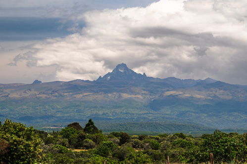 Ewaso Nyiro. Mount Kenya is an exceptional destination for seasoned hikers, botanists, photographers and birdwatchers. The mountain offers a distinctive alpine climbing experience characterized by technical ascents, glacial valleys, and striking ecological zones that transition dramatically with changes in altitude.
In this guide, we provide practical insights into hiking Mountain Kenya. We will share practical knowledge with prospective hikers on how to prepare and what to consider as packing essentials. The article will provide guidance on route selection, ecological considerations and safety protocols. You might want to read about Hiking Kilimanjaro or Climbing the Rwenzori Ranges of Mountains.
Why Climb Mount Kenya?
Technical Alpine Climbing Experience: Mount Kenya presents a specialized climbing experience distinguished by technical rock ascents, particularly on its highest peaks Batian (5,199 meters) and Nelion (5,188 meters). Unlike many of Africa’s other high-altitude climbs, reaching the summit requires advanced climbing skills. Climbing skills should include mastery of rock-climbing techniques, proficient use of ropes, anchors, harnesses and comprehensive route navigation abilities. This technical aspect positions Mount Kenya as a sought-after climbing destination among serious mountaineers and those eager to challenge themselves beyond standard trekking ascents.
 Exceptional birdwatching opportunities: Mount Kenya serves as an important ecological hotspot for avian species adapted to high-altitude ecosystems. Birdwatchers gain access to numerous altitude-specific and endemic species rarely observed elsewhere. These include the Abbott’s Starling, Jackson’s Francolin, Mount Kenya Starling and Scarlet-tufted Sunbird. These species can be observed within their natural habitats (montane forests and alpine moorlands) hence enriching the climbing experience for bird-focused expeditions.
Lower Climber traffic and enhanced wilderness experience: Compared to Kilimanjaro and other prominent peaks, Mount Kenya experiences considerably lower climber traffic. This affords a more private and undisturbed climbing experience. The limited number of climbers allows for meaningful interactions with wildlife, undisturbed photographic opportunities and comprehensive ecological exploration. Climbers frequently find themselves in solitude, enabling precise observation of animal behavior and vegetation adaptations. All that creates a more authentic wilderness experience.
Understanding Mount Kenya’s Geography
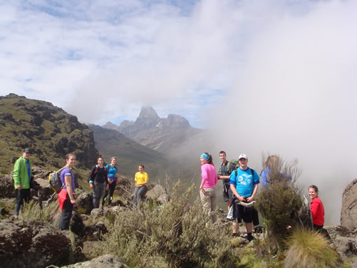
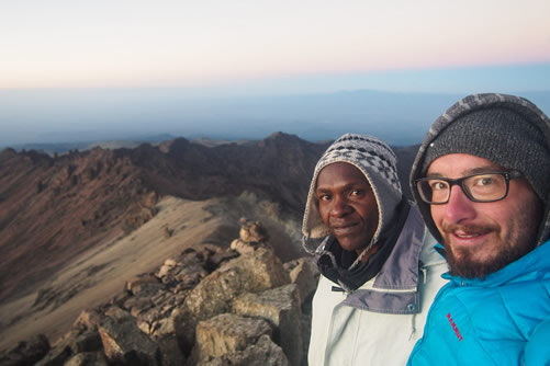
Mount Kenya features three prominent summits, each with its own distinct climbing requirements and technical considerations. The highest peak is Batian (5,199 meters). This peak demands rigorous alpine 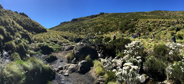 climbing skills, including technical rock-climbing proficiency, effective rope management, and the capability to navigate complex routes.
The second-highest summit is Nelion (5,188 meters). This similarly requires advanced technical expertise and is often ascended alongside Batian. The two are connected by a challenging rock traverse known as the “Gate of the Mists”.
The third summit is Point Lenana (4,985 meters) which is accessible to non-technical climbers and represents the common goal for most climbing expeditions. Lenana is suitable for individuals possessing moderate hiking and altitude management capabilities.
Altitude and Climatic Zones while Climbing Mount Kenya
Mount Kenya is characterized by distinct ecological zones differentiated primarily by altitude and climatic conditions. Climbing from base to summit involves traversing through clearly demarcated zones, each exhibiting specialized flora and fauna adapted uniquely to their respective altitudes:
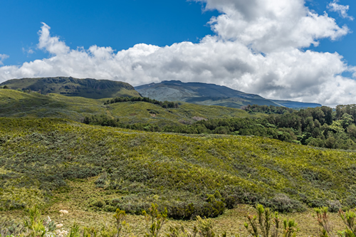
 Montane Forest Zone (1,800 – 2,500 meters): Characterized by dense montane forests inhabited by species such as bushbucks, elephants, forest hogs and diverse birdlife (including turacos and hornbills). Temperatures here remain mild with frequent rainfall and mist. These conditions require climbers to adopt suitable clothing and moisture management strategies.
Bamboo and Hagenia Zone (2,500 – 3,000 meters): This zone hosts forests primarily consisting of bamboo stands interspersed with Hagenia trees. Birdwatchers often encounter bird species adapted specifically to these highland forests like the Hartlaub’s Turaco. Climatic conditions include cooler temperatures, frequent cloud cover and considerable moisture retention.
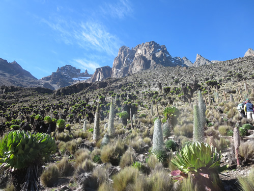
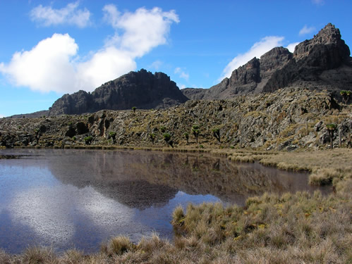
Heath and Moorland Zone (3,000 – 3,800 meters): At this altitude, vegetation transitions to heathland comprising giant heathers, tussock grasses, and unique botanical species such as giant lobelias and groundsel. Climbers experience significantly cooler temperatures, stronger winds and lower oxygen levels. These conditions demand effective layering of clothing and heightened altitude management.
 Alpine Zone (3,800 – 4,500 meters): Vegetation is sparse and dominated by small alpine plants. These hardy species are capable of surviving intense exposure to wind, cold temperatures and limited oxygen. Climbers must anticipate potential altitude sickness symptoms here including headaches, nausea, fatigue, necessitating careful acclimatization planning and hydration protocols.
Glacial and Rocky Summit Zone (4,500 meters and above): The highest points on Mount Kenya are rocky (rugged rock faces) with steep slopes and residual glaciers. Climbers confront sub-zero temperatures, risk of ice/snow, potential rockfall hazards and rapidly changing weather conditions. Technical climbing proficiency, proper equipment (crampons, ropes, helmets, and harnesses) and expert guidance are essential.
Climbing Mount Kenya – Routes to the Summit
Selecting the most suitable route is a critical component of successful Mount Kenya ascents. Each established climbing path offers distinctive challenges, scenery and technical demands. These demands must align with climbers’ abilities, objectives and expectations.
Sirimon Route: The Sirimon Route which originates from the northwestern side of Mount Kenya (near Nanyuki town) offers the most gradual altitude ascent. The route is highly advantageous for acclimatization. This route is particularly suitable for first-time climbers and birdwatchers aiming to maximize wildlife observation opportunities. Moderate hiking skills are required for the Sirimon Route until reaching higher elevations near Lenana Peak.
The Sirimon Route Commences at the Sirimon Gate (2,650 meters), ascending steadily through montane forests, bamboo and moorland zones. It then passes the Old Moses Camp (3,300 meters) and eventually reaches Shipton’s Camp (4,200 meters) which is a key acclimatization and resting point. Climbers typically ascend Point Lenana via scree slopes and rock paths from Shipton’s Camp.
How long does it take to reach the peak using the Sirimon Route? The Standard ascent and descent duration are approximately 4 to 5 days, allowing effective altitude acclimatization and ecological exploration. The Sirimon Route has accessible trails with Outstanding wildlife viewing opportunities, scenic alpine flora and photographic vistas ( like the Mackinder’s and Likii North Valleys).
Chogoria Route: The Chogoria Route starts from the mountain’s eastern side (near Chogoria town). It is considered the most scenic ascent consisting of panoramic views and unique geological formations. It demands moderate physical fitness and careful acclimatization practices. No advanced technical climbing skills are required until the final ascent to Point Lenana. This area includes rocky terrain and steep slopes.
 The Chogoria Route initiates at the Chogoria Gate (2,950 meters), then ascends through dense montane forests to Lake Ellis (3,500 meters). It then proceeds to the glacial Lake Michaelson (4,000 meters) and eventually arrives at the Mintos Hut (4,300 meters). The final ascent to Point Lenana is usually undertaken before dawn and involves navigating steep rocky scree and slopes.
How long does it take to reach the summit using the Chogoria Route? It generally requires 4 to 6 days for adequate acclimatization and full enjoyment of ecological and geological points of interest. Hikers are rewarded with spectacular views of glacial lakes like Michaelson, the Nithi Falls and diverse vegetation zones. The Chogoria Route is a birders paradise.
Naro Moru Route: The Naro Moru Route is the shortest and most direct path to Point Lenana. It can be approached from the mountain’s western side (near Naro Moru town). It’s a favorite with climbers looking to complete the hike in the shortest time possible. Despite its popularity (due to accessibility), it presents a steep and physically demanding ascent. How does a normal hike look like using this route? Hiking starts from the Naro Moru Gate (2,400 meters), then rapidly upward through montane forests, bamboo and heather zones. The Met Station is approached at 3,050 meters. Climbers then proceed through the steep and challenging vertical bog area known as the “Vertical Mud” before reaching Mackinder’s Camp (4,200 meters). The final route to the summit follows steep scree slopes.
Hiking Mount Kenya using this route is normally completed in 3 to 4 days. This makes it ideal for shorter climbing schedules but requires careful management of altitude due to the rapid elevation gain involved. Hikers are rewarded with direct access to Lenana summit, impressive alpine scenery and efficient route layout.
Burguret Route: The Burguret Route is Mount Kenya’s least travelled trail. It’s ideal for climbers desiring genuine wilderness solitude and minimal human interference. Burguret Route is known for challenging navigation due to limited trail markings which demand advanced route-finding skills or professional guides. In general, hiking through this route is more difficult due to unclear paths and dense undergrowth. Because of the route-finding challenges, it is recommended for experienced hikers or under the Guidance of experienced Guides.
How is a normal hike like using this route? Entry is via the Burguret Gate (about 2,500 meters) before beginning to ascend through dense montane forests and isolated wilderness terrain. Hikers go through largely undefined trails before connecting with the main paths close to the moorland zone. They then converge at Mackinder’s Camp or Shipton’s Camp to get to Point Lenana. Reaching the summit requires between 5 to 7 days. That is more than enough time for acclimatization, exploration and careful route navigation.
Burguret Route is preferred by Climbers because of the minimal human presence, wilderness isolation, opportunities to observe wildlife, ecological exploration and wildlife observation chances.
Best Time to Climb Mountain Kenya
Selecting the optimal climbing period is critical for ensuring a successful and safe Mount Kenya ascent. Climatic patterns in the region influence trail accessibility, visibility, climbing safety and overall quality of the experience. It is essential for climbers and birdwatchers to plan carefully based on prevailing conditions.
 Dry Seasons (January to March and July to October): Mount Kenya’s most ideal climbing conditions occur during two distinct dry seasons – From late December through March and from July to October. These periods offer clear skies, minimal precipitation and stable climbing conditions. These conditions significantly reduce weather-related challenges. Visibility tends to be excellent during this season hence allowing detailed observation of geological features, wildlife and birds species. It is also an excellent season for photography. During these dry seasons, there are reduced risks of slippery/muddy conditions. However, despite generally favorable weather conditions, hikers should always be prepared for unexpected cold/snow or storms at high altitude.
Rainy Seasons (April to June and November to Mid-December): Climbing during the wet seasons (Especially between April to June and November to mid-December) poses increased difficulties. Frequent heavy rains, thick cloud cover, limited visibility and colder temperatures create challenging conditions. The trails often become slippery, muddy, and occasionally impassable, increasing the risk of accidents or delays. Whereas these months offer fewer crowds and solitude, one must be well prepared/cautious. Birdwatchers will find hiking during the rainy seasons rewarding but weather conditions will restrict extensive exploration especially at higher altitudes.
Climbing Mount Kenya – Temperature and Weather Considerations
Temperatures on Mount Kenya vary significantly based on elevation. It drops to approximately 6°C for every 1,000-meter increase. At higher altitudes, night temperatures regularly fall below freezing. Climbers should always anticipate rapid weather fluctuations especially beyond 3,500 meters. They should prepare for cold conditions, strong winds, potential snowfall and occasional hailstorms.
Packing List for Hiking Mount Kenya
Packing appropriately for your Mount Kenya ascent ensures safety, comfort and preparedness for changing alpine conditions. Below is a concise checklist detailing essential equipment and supplies:-
Clothing: Ensure that you pack waterproof hiking boots with robust ankle support. Consider Thermal base layers (leggings and long-sleeved shirts), Insulating mid-layer (synthetic jacket or fleece), Waterproof or wind-resistant outer jacket/pants and synthetic thermal or woolen socks. Don’t forget warm gloves and insulated hat.
Climbing and Hiking Gear: Remember to move with a backpack, climbing harness/helmet, Ice axe and crampons. Have trekking poles for stability/balance and always move with a headlamp.
Camping Equipment: Remember to acquire alpine tents, sleeping bag (suitable for sub-zero temperatures), insulated sleeping mats, for warmth and comfort. Climbers should ensure that they have a portable cooking stove and fuel. Then there are cooking utensils (plates, cups and cutlery)
Hydration and Nutrition: All hikers should ensure that they pack energy-rich snacks (chocolate, nuts, energy bars and dried fruit) when climbing Mount Kenya. To stay hydrated, they should consider freeze-dried meals, powder for hydration and electrolyte tablets. A portable water filtration system or water purification tablets with reusable insulated water bottles will enhance the quality of the hike.
Personal Items and Hygiene: High-altitude UV protection sunglasses, sunscreen and lip balm (with UV protection) are some of the things to consider packing when planning to climb Mount Kenya. Hikers should also consider personal hygiene products like hand sanitizer, wipes, biodegradable soap and quick-drying towel. We shouldn’t forget mentioning basic first aid kit with altitude related medication.
Navigation and Emergency Supplies: For perfect navigation when hiking Mount Kenya, ensure that you have a topographic map, satellite phone, reliable compass/GPS device and topographic map. Do not forget to move with your documents for personal identification and permits. You might also want to consider packing a whistle for emergency signaling and waterproof bags.
Mount Kenya offers an exceptional mountaineering experience which is distinguished by its unique ecological and cultural attributes. With diligent planning and informed preparation, climbers can successfully navigate the complexities and be rewarded with an amazing experience of this African peak.